Upload presentasi
Presentasi sedang didownload. Silahkan tunggu

1
Spatial Thinking Geography…… has meant different things to different people at different times and in different places (livingstone, 1992 dalam Hubbard, et.al, 2004)
")
2
Sense of Place Setiap manusia (normalsense) memiliki sense of place Perkembangan sense of place seseorang: Jenis kelamin, umur, kesehatan, kemampuan finansial Place Berkaitan dengan lokasi dan integrasi antara masyarakat, budaya dan alam Fisik Nilai/kepercayaan, keturunan, keperibadian Psikologis Pengalaman/ pengetahuan Tingkat pendidikan, sosialisasi

3
Environmental Structure
The Human-Environment Behavioral Interface Environmental Structure I n t e r f a c e Change in the system Perception Cognition Attitudes Learning Behavior with the system changes the interface Spatial behavior Golledge, 1997

4
Tempat kita selalu berubah
Tempat (place) : suatu lokasi sebagai wujud dari integrasi masyarakat, budaya dan bentang alamnya ada satu hubungan yang sistematis antara individu dan komponen landscape (Lowenthal, 1989) Pemahaman landscape dapat dibagi dalam 4 perspektif paradigma: The Expert Paradigm applications design for use by managers and planners The Psychological Paradigm meaning in the perception of landscapes (value stimulation) The Cognitive Paradigm meaning in landscape in human terms (construct of human mind) The Experiential Paradigm meaning of human landscape interactions (human environment interaction)
 : suatu lokasi sebagai wujud dari integrasi masyarakat, budaya. dan bentang alamnya. ada satu hubungan yang sistematis antara individu dan. komponen landscape (Lowenthal, 1989) Pemahaman landscape dapat dibagi dalam 4 perspektif paradigma: The Expert Paradigm applications design for use by managers and planners. The Psychological Paradigm meaning in the perception of landscapes (value stimulation) The Cognitive Paradigm meaning in landscape in human terms (construct of human mind) The Experiential Paradigm meaning of human landscape interactions (human environment interaction)")
5
The Nature of Spatial Knowledge
Declarative component: pengetahuan akan makna obyek dan tempatnya Relational and configurational hubungan keruangan (spatial relationship) diantara pengembangan obyek dan tempatnya Procedural knowledge menggambarkan proses perkembangan perubahan obyek dalam konteks keruangan
 diantara pengembangan obyek dan tempatnya. Procedural knowledge. menggambarkan proses perkembangan perubahan obyek dalam konteks keruangan.")
6
Environmental cognition
Spatial Cognition dan Mental Maps Sense of Place Environmental cognition Spatial Cognition Cognitive mapping Mental Maps Social Mapping Suatu proses transformasi psikologis yang diharapkan, disimpan, recalls dan decodes information tentang lokasi dan atribut dari satu fenomena kejadian kehidupan sehari-hari.

7
Westerners Orientation
Cognitive impact on Behavior Pattern Ecology Ecology Economy Economy Social Structure Social Structure Attention Attention Metaphysics Metaphysics Epistemology Cognitive Process Epistemology Cognitive Process Asians Orientation Westerners Orientation How Asians and Westerners Think Differently and WHY (Richard E. Nisbett, 2003)
")
8
Apakah Ruang ? PANDANGAN FILSUF ILMU ALAM
Ruang adalah realitas fisik yang tidak dipengaruhi oleh benda-benda di dalamnya dan oleh bagaimana benda-benda tersebut dipahami PANDANGAN FILSUF ILMU SOSIAL (HUMANIS) Ruang adalah setting bagi tindakan manusia, di mana manusia dapat merancang dan mengendalikan
 Ruang adalah setting bagi tindakan manusia, di mana manusia dapat merancang dan mengendalikan.")
9
Apakah Ruang ? DALAM KEPENTINGAN PERENCANAAN
Baik secara praktis maupun ilmiah, selama berkaitan dengan kehidupan manusia, pengertian ruang selalu terkait dengan permukaan bumi Batas atas dan batas bawah adalah hingga ketinggian/kedalaman tertentu selama masih mempengaruhi permukaan bumi (kehidupan manusia)
")
10
Ruang & Keruangan Ruang (space) Kata benda
Merujuk pada “obyek” perencanaan Keruangan (spatial) Kata sifat Merujuk pada “karakter” perencanaan Jadi... Perencanaan spasial seharusnya tidak diterjemahkan sebagai “kegiatan merencanakan ruang” Perencanaan spasial adalah perencanaan yang dilakukan berdasarkan perspektif, sudut pandang, atau pendekatan spasial
 Kata sifat. Merujuk pada karakter perencanaan. Jadi... Perencanaan spasial seharusnya tidak diterjemahkan sebagai kegiatan merencanakan ruang Perencanaan spasial adalah perencanaan yang dilakukan berdasarkan perspektif, sudut pandang, atau pendekatan spasial.")
11
Apakah Pendekatan Spasial?
Pendekatan Spasial: memahami, mengkaji, dan menilai lokasi/tempat keberadaan aktivitas manusia di permukaan bumi Melalui pertanyaan : Where is it? Why is it there? Jawaban atas pertanyaan di atas akan membantu kita dalam memahami keterkaitan keruangan (spatial relationship) antara sistem fisik dan sistem sosial dalam membentuk karakteristik permukaan bumi
 antara sistem fisik dan sistem sosial dalam membentuk karakteristik permukaan bumi.")
12
Tema penting pendekatan spasial
LOKASI Lokasi absolut (Lintang, Bujur) & lokasi relatif TEMPAT Lokasi + karakteristik REGION (WILAYAH) Memiliki keunikkan tersendiri Pengelompokkan lokasi yang memiliki karakteristik sama JARAK Jarak absolut (metrik) & jarak relatif (jarak sosial) ARAH Arah absolut (arah mata angin) & arah relatif (orientasi subyektif) SKALA Ukuran permasalahan (global, nasional, regional, lokal, individu) POLA DAN PROSES Inter-relasi dan intra-relasi keruangan
 & lokasi relatif. TEMPAT. Lokasi + karakteristik. REGION (WILAYAH) Memiliki keunikkan tersendiri. Pengelompokkan lokasi yang memiliki karakteristik sama. JARAK. Jarak absolut (metrik) & jarak relatif (jarak sosial) ARAH. Arah absolut (arah mata angin) & arah relatif (orientasi subyektif) SKALA. Ukuran permasalahan (global, nasional, regional, lokal, individu) POLA DAN PROSES. Inter-relasi dan intra-relasi keruangan.")
13
The Spatial Tradition Focuses on where things are and why they are there Asks about patterns and processes of human occupancy of the earth’s surface Concerned on explanation and prediction of the general rather than description & understanding of the particular phenomenon

14
Perspektif Spasial Aktivitas manusia selalu terkait dengan ruang permukaan bumi Perencanaan berdasarkan fakta spasial (distribusi, pola, struktur, pergerakan, dan sistem keruangan) Pertanyaan pokok : Apa? Di/ke mana ? Mengapa (harus) di/ke sana ?
 Pertanyaan pokok : Apa Di/ke mana Mengapa (harus) di/ke sana")
15
Perspektif Spasial POLA KERUANGAN Variasi Keruangan
Tanah di Jawa lebih subur dari pada Sumatera karena gunung api di Jawa yang lebih muda umurnya Struktur Keruangan Struktur ruang Indonesia bagian barat, lebih kompak di bandingkan dengan Indonesia bagian timur Keterkaitan Keruangan Timbulnya pertukaran komoditas antara Jawa dan NTT. Jawa mengirim beras ke NTT, sebaliknya NTT mengirim ternak ke Jawa

16
Kategori Klasifikasi

17
Ruang dan Pembangunan Space as region :
Area that is considered different from other areas according to specified characteristices (can be identified and mapped on the basis of any phenomenon) Showing uniqueness of certain place to support human activities
 Showing uniqueness of certain place to support human activities.")
18
What is Region? Region has location Region has spatial extent
Area of the earth’s surface marked by certain properties. Based on an established criteria: Human (cultural) properties Physical (natural) properties Region has location Region has spatial extent Region has boundaries Region has hierarchically arranged
 properties. Physical (natural) properties. Region has location. Region has spatial extent. Region has boundaries. Region has hierarchically arranged.")
19
Region as spatial unit analysis
Framing the size of the problem Depend on scale Choice of scale frames, choice of solutions Image from Center for Alternative Development Initiatives

20
Types of Region Formal region
Marked by a certain degree of homogeneity in one or more phenomena. Also called a uniform region or homogeneous region. Functional region A region marked less by its sameness than its dynamic internal structure. A spatial system focused on a central core. A region formed by a set of places and their functional integration. Also called a “nodal” region

21
Examples of Formal Region

22
Examples of Functional Region

23
Assessing Space Landscape understanding
Spatial setting ; refers to spatial orientation based on spesific location Spatial attribute ; refers to physical and human characteristics Spatial dynamic ; refers to spatial process and pattern of the changing world (spatial-temporal understanding) Why do some industries are concentrated in one particular region ? Why does the city of Jakarta has experienced rapid urbanization more than other cities in Indonesia ?
 Why do some industries are concentrated in one particular region Why does the city of Jakarta has experienced rapid urbanization more than other cities in Indonesia")
24
Spatial Setting Strategic location Spatial lingkages

25
Spatial Attribute Indonesia, attributed as a suitable region for agriculture activities Indonesia, attributed as a vulnarable region of natural disaster

26
Spatial Dynamic Driven by : Population Economic activities Technology
etc

27
Contoh Identifikasi Isu
REGIONAL SETTING Sumatera bagian barat Menghadap ‘dunia kosong’ Bentuk medan berat Relatif lebih sepi dari dinamika ekonomi FENOMENA PEMBANGUNAN WILAYAH Merupakan provinsi yang mengalami keterpencilan. Walaupun terletak di antara provinsi yang cukup maju, tetapi kinerja perekonomiannya mengalami ketertinggalan. Memiliki ketergantungan yang sangat besar terhadap produk-produk primer perkebunan dan pertambangan. Daya dukung infrastruktur dan tingkat pemanfaatannya tidak mencapai skala ekonomi yang menguntungkan. Provinsi Bengkulu Dijepit oleh samudra dan pegunungan 50% berupa hutan Wilayah datar sempit Berada di tengah-tengah Sumbar, Sumsel, dan Lampung Orientasi : Palembang Jalur lintas barat Sumatera ISU PEMBANGUNAN WILAYAH : Keterpencilan wilayah dan keterbelakangan ekonomi Provinsi Bengkulu REGIONAL ATTRIBUTE (Bengkulu) Penggunaan tanah didominasi hutan lindung Perkebunan dan pertambangan berperan penting. Kegiatan industri masih sangat terbatas Banyak terjadi economic leakages Infrastruktur jalan relatif baik Aktivitas perhubungan udara dan laut relatif terbatas Suplai tenaga listrik terbatas
 Penggunaan tanah didominasi hutan lindung. Perkebunan dan pertambangan berperan penting. Kegiatan industri masih sangat terbatas. Banyak terjadi economic leakages. Infrastruktur jalan relatif baik. Aktivitas perhubungan udara dan laut relatif terbatas. Suplai tenaga listrik terbatas.")
28
What is planning “Planning is the process of preparing, in advance, and in a reasonably systematic fashion, recommendations for policies and courses of action, with careful attention given to their possible by-products, side effects, or ‘spillover effects.’” Coleman Woodbury, late professor in planning at UW-Madison

29
Mengapa Perencanaan Spasial ?
Alasan Eksistensial Setiap manusia di mana pun bertempat tinggal memiliki naluri alamiah untuk mengenal lingkungan tempat tinggalnya Alasan Etis Pemahaman akan adanya saling ketergantungan antara manusia dan komponen lingkungan lainnya merupakan basis untuk menjaga keberlanjutan kehidupan Alasan Ilmiah Perspektif keruangan akan menimbulkan rasa ingin tahu tentang perbedaan dan persamaan kehidupan di berbagai belahan bumi. Alasan Praktis Pemahaman akan adanya keterkaitan manusia-lingkungan serta adanya perbedaan dan persamaan ruang kehidupan menjadi alasan untuk mengupayakan kehidupan masa depan yang lebih baik

30
Perencanaan adalah tentang...
Pembelajaran guna menangkap aspirasi setempat Menciptakan kesempatan yang lebih baik bagi masyarakat pada suatu wilayah Mengkaji sampai sejauh mana dampak terhadap keseimbangan & keberlanjutan kehidupan (penduduk dan lingkungan) Mengkaji dan menyampaikan gambaran masa depan
 Mengkaji dan menyampaikan gambaran masa depan.")
31
Sehingga... Perencanaan Dimulai dengan fakta yang dikaitkan dengan tujuan, agar dapat ditetapkan arah kebijakannya. Critical point-nya adalah Menyusun hubungan optimal antara input, proses, dan output / outcomes

32
Syarat penting - Akurasi
Berkaitan dengan fakta, arah, dan tujuan; Fakta = titik awal Arah = rambu-rambu Tujuan = hasil akhir dalam periode tertentu Ditentukan oleh ketepatan dan kehandalan data, metode analisis, intepretasi data, dan penyajian hasil a) Titik awal dan tujuan, tanpa arah b) Titik awal dan arah, tanpa tujuan c) Arah dan tujuan, tanpa titik awal d) Titik awal, arah dan tujuan Titik awal Tujuan Arah
 Titik awal dan tujuan, tanpa arah. b) Titik awal dan arah, tanpa tujuan. c) Arah dan tujuan, tanpa titik awal. d) Titik awal, arah dan tujuan. Titik awal. Tujuan. Arah.")
33
Tahapan perencanaan Masalah Data Analisis Fakta Fakta - Sasaran
Akurasi Akademik Birokrasi Fakta - Sasaran Kebijaksanaan Program/Proyek Legitimasi Dana Tanah Pelaksanaan MonEv Lapor

34
Dari masalah ke kebijakan
Data Data disistimatisir Analisis Kebijaksanaan Apa? Di mana? Berapa? Kenapa? Kapan? dsb Kuesioner Observasi Survai Korelasi Asosiasi dsb a. b. c. Pengwilayahan (regionalisasi) A Pembangunan harus diselaraskan dengan kebutuhan regional B Masalah Data Data disistimatisir Analisis Kebijaksanaan Pengwilayahan (regionalisasi) Apa? Di mana? Berapa? Kenapa? Kapan? dsb
 A. Pembangunan harus diselaraskan dengan kebutuhan regional. B. Masalah. Data. Data disistimatisir. Analisis. Kebijaksanaan. Pengwilayahan (regionalisasi) Apa Di mana Berapa Kenapa Kapan dsb.")
35
Region dan Perencanaan Spasial
Versi 1 : Region sebagai tujuan akhir (region obyektif) Dasar asumsi : manusia sangat tergantung pada kondisi lingkungan sehingga harus menyesuaikan diri dengan setiap perubahan yang terjadi. Paham linearitas : region berubah, maka kehidupan akan berubah pula Region yang harus dicapai, bila tidak maka kehidupan akan “kacau” The fate of society depends on the felttip of the planner (Hartshorne)
 Dasar asumsi : manusia sangat tergantung pada kondisi lingkungan sehingga harus menyesuaikan diri dengan setiap perubahan yang terjadi. Paham linearitas : region berubah, maka kehidupan akan berubah pula. Region yang harus dicapai, bila tidak maka kehidupan akan kacau The fate of society depends on the felttip of the planner (Hartshorne)")
36
Region dan Perencanaan Spasial
Versi 2 : Region adalah penggolongan muka bumi (region subyektif) Region bukan tujuan akhir, melainkan cara untuk mencapai tujuan Region dibentuk berdasarkan “fakta”, bukan berdasarkan “harapan” “Effective regional study is founded on the selection of meaningful criteria (Whittlesey)
 Region bukan tujuan akhir, melainkan cara untuk mencapai tujuan. Region dibentuk berdasarkan fakta , bukan berdasarkan harapan Effective regional study is founded on the selection of meaningful criteria (Whittlesey)")
37
Region dan Perencanaan Spasial
Region = Spatial Elementary Unit Dasar bagi intepretasi spasial Regionalisasi adalah mengklasifikasikan tempat-tempat yang memiliki fakta yang sama. Tempat = lokasi + karakteristik Region = wilayah fakta Regionalisasi = periodisasi dalam pendekatan sejarah

38
Contoh Penerapan Masalah Mau Membangun A B C A B C A B C A B C D E F D
Atau Mau Membangun Apa? : Menggali saluran pengairan dengan padat karya Di mana? : lihaf fakta yang ada Region pengangguran banyak Region sawah 1 x panen setahun Region hujan sedikit Region jaringan saluran air sedikit Berapa? : Akan dihitung segera Kenapa? : Berdasarkan fakta yang ada Kapan? : Pada musim kemarau tahun ini 1 x panen setahun Kurang dr 1500 mm/thn 1 m/10 km2 A B C A B C A B C A B C 75% 50% mm/thn D E F D E F D E F D 1 m/5 km2 E F 2 x panen setahun Lebih dr 2000 mm/thn 25% G H I G H I G H I 1 m/2 km2 G H I Tk. Pengangguran Sawah Hujan Jaringan saluran air Kesimpulan : Saluran akan dibuat di kecamatan-kecamatan B dan C (prioritas 1) serta E dan F (prioritas 2)
 serta E dan F (prioritas 2)")
39
distortion and deception “how to lie with maps”
most obvious being through data selection/omission projections how are maps of cyberspace deceiving? Clearly there are many ways to project cyberspace onto a map

40
maps as frames of space

41
interfaces as frames of virtual space

42
virtual maps make virtual space
the map affects what we see and what we can do we never know virtual space for ‘real’ the interface is the space map and the territory are one those who make the interface, make the space… and of course the map they make is subjective and serves their interests its easy to take the interface for granted, assuming it is natural and a given. do not recognise its artificiality

43
‘global’ [political economy]
- power - interests - consumption - closure $$$ ££££ $$$ ££££ ‘local’ [social constructivist] - authorship - objectives - contexts ‘the map’ - subject - rhetoric - accuracy - ethics - space $$$ ££££ methodology for critique
![‘global’ [political economy]](http://slideplayer.info/slide/3223247/11/images/43/%E2%80%98global%E2%80%99+%5Bpolitical+economy%5D.jpg "- power. - interests. - consumption. - closure. $$$ ££££ $$$ ££££ ‘local’ [social constructivist] - authorship. - objectives. - contexts. ‘the map’ - subject. - rhetoric. - accuracy. - ethics. - space. $$$ ££££ methodology for critique.")
44
Social spaces Information spaces Infrastructure

45
Karya Martin Dodge Oct. 2001 Sept. 2000

46
Contoh cybergeography

47
Contoh cybergeography

48
Perubahan Landscape di Perkotaan
Urban Places (based on buildings, Urban electronic spaces (constructed ‘inside’ telematics network using computer software Teritory Network Fixity Motion/flux Embedded Dis-embedded Visible Invisible Tangible Intangible Actual Virtual/abstract Euclidean social space Logical space

49
New concept approaches for the Telecommunication based city
Old Characterisations New Characterisation Space of places Space of flows (Castells, 1989) Physical presence Telepresence (CEC, 1992) Physical Mediation Telemediation (Richardson, 1994) Geography Telegeography (Staple, 1992) Distance Speed and Time (Mulgan, 1991) Closure Openness and exposure (Virilio, 1987) Locality Globality (Knight and Gappert, 1989) “Modern space” Post-Modern ‘Hyperspace’ (Jameson, 1984) Data spaces (Murdock, 1993) Electronics spaces (Robbins & Hepworth, 1988) Cyberspace (Gibson, 1984) Netscape (Hemrick, 1992) Networld (Harasim, 1993)
 Physical presence Telepresence (CEC, 1992) Physical Mediation Telemediation (Richardson, 1994) Geography Telegeography (Staple, 1992) Distance Speed and Time (Mulgan, 1991) Closure Openness and exposure (Virilio, 1987) Locality Globality (Knight and Gappert, 1989) Modern space Post-Modern ‘Hyperspace’ (Jameson, 1984) Data spaces (Murdock, 1993) Electronics spaces (Robbins & Hepworth, 1988) Cyberspace (Gibson, 1984) Netscape (Hemrick, 1992) Networld (Harasim, 1993)")
50
Aplikasi Analisa Lokasi untuk Pemasaran
Perdagangan (Merchandise) & Mix Analysis Segmentasi toko/outlet Analisa Promosi Rencana Merger & Akuisisi Pemilihan Lokasi Rencana Jejaring Pemetaan Pasar Analisa Kompetitor Sistem Pendukung Pembuatan Keputusan Spatial (Spatial Decision Support System/ SDSS) Modelling, analisis dan visualisasi Gudang Data Spatial (Spatial Data Warehouse) Data Fusion and Management Demand side Data Supply-side Data Pusat kawasan belanja Penamaan daerah: Kebayoran Waralaba Kode Pos Alamat ISIC Suku Toko Internal Client Data Eksternal Nama Suku Pendapatan Skala Unit Record Data (example) Aggregate Data Aggregate Data Unit Record Data (example) Format Waktu Buka Waktu Tutup Mall Ruko Status Daerah sensus kota Propinsi Pengeluaran Pekerjaan
 & Mix Analysis. Segmentasi toko/outlet. Analisa Promosi. Rencana Merger & Akuisisi. Pemilihan Lokasi. Rencana Jejaring. Pemetaan Pasar. Analisa Kompetitor. Sistem Pendukung Pembuatan Keputusan Spatial. (Spatial Decision Support System/ SDSS) Modelling, analisis dan visualisasi. Gudang Data Spatial (Spatial Data Warehouse) Data Fusion and Management. Demand side Data. Supply-side Data. Pusat kawasan belanja. Penamaan daerah: Kebayoran. Waralaba. Kode Pos. Alamat. ISIC. Suku. Toko. Internal. Client Data. Eksternal. Nama. Suku. Pendapatan. Skala. Unit Record Data (example) Aggregate Data. Aggregate Data. Unit Record Data (example) Format. Waktu Buka. Waktu Tutup. Mall. Ruko. Status. Daerah sensus kota. Propinsi. Pengeluaran. Pekerjaan.")
51
Mengukur Manfaat Bisnis GIS
Save money/ cost avoidance Save time Increase efficiency Increase accuracy Increase productivity Generate revenue Support decision making Aid budgeting Automate workflow Build an Information Base Manage resource Improve access to government Increase communication and collaboration Sumber: Thomas dan Ospina (ESRI), 2004
,")
52
Manfaat GIS dalam Matriks Industri (pengalaman ESRI)
Communication and collaboration Improve access to government Save money/ cost avoidance Build an information base Support decision making Increase productivity Automate workflow Increase efficiency Increase accuracy Generate revenue Manage resources Aid budgeting Save time Manfaat GIS dalam Matriks Industri (pengalaman ESRI) Business banking and insurance media real estate Government administration/management cadastral economic development electronic finance health and human services law enforcement and criminal justice Natural Resources agriculture forestry Transportation logistics and fleet management transportation systems and network Utilities electric and gas telecommunication
 Business. banking and insurance. media. real estate. Government. administration/management. cadastral. economic development. electronic. finance. health and human services. law enforcement and criminal justice. Natural Resources. agriculture. forestry. Transportation. logistics and fleet management. transportation systems and network. Utilities. electric and gas. telecommunication.")
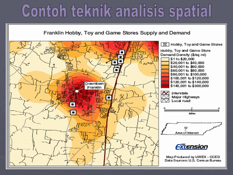
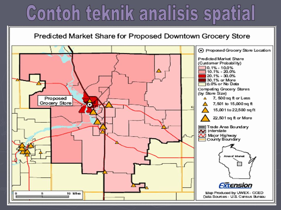
53
Contoh teknik analisis spatial
54
Contoh teknik analisis spatial
55
Contoh hasil analisa supply side, demand side, competitive level dan optimal service location/area Recommendation: Premium Location A. Premium targeted service area Alternative 1 location B. Secondary targeted service area Alternative 2 location C. Promising targeted service area

56
Peta dari masa ke masa

57
Figure 7:2 Skills matrix for geographers, University of Leeds, 1998
Knowledge Analysis Synthesis Evaluation Creativity Professionalism Level of Year Broad knowledge and understanding of areas of Geography. Fluency in subject vocabulary Problem solving ability. Evidence of understanding. Ability to apply concepts to novel situations. Ability to bring together different facets of material, and to draw appropriate conclusions. Ability to review, assess and criticise one's own work and that of others in a fair and professional manner. Ability to make an original, independent, personal contribution to the understanding of the subject. Ability to act as a practising geographer, to present argument in a skilled and convincing manner and to work alone or in teams 1 Demonstrate a basic understanding of core subject areas, happy with geographical terminology. Demonstrate a knowledge of appropriate supporting analytical techniques (stats., computing, lab and field techniques ..) Apply geographical techniques to real situations through class and field examples. Understand that there may be unique or multiple solutions to any issue. Appreciate relative validity of results. Be able to handle material that presents contrasting views on a topic and develop personal conclusions. Draw conclusions from results and identify the relative significance of a series of results. Evaluate the accuracy and reliability of information, results and conclusions. Offer original comment on geographical material. Display or present information in different ways. Be effective in planning time, use of geographical resources including library, computer packages including databases. Present information orally, and written to a high standard. 2 Demonstrate a comprehensive knowledge of specific subject areas. Be able to question the accuracy and completeness of information. Appreciate how different parts of the subject inter-relate. Apply geographical theories to individual situations critically examine the results. Understand that it may be appropriate to draw on multi- disciplinary approaches to analyse and solve geographical problems. To locate and comment on diverse material, add personal research observations and integrate literature based information with personal results. Review existing literature and identify gaps, appraise the significance of results and conclusions. Develop original independent research skills, interpret data and offer personal comment. Be able to display information in a variety of ways. Confident use of computer packages for analysis and information presentation. Confident worker in group and collaborative activities. Produce written work to a high professional standard. 3 Demonstrate a deep understanding of a limited number of specialised subject areas and methods. Appreciate the provisional state of knowledge in subject areas. Understand how to solve problems with incomplete information, how to make appropriate assumptions. To develop appropriate research hypotheses. Question and verify results. Appreciate the breadth of information available. To identify and tap into key elements of the material. Produce coherent reports. Critically appraise information, evidence and conclusions from personal and others work. Gather new information through personal research, draw personal conclusions and show where these insights link to the main subject areas. Be able to set objectives, focus on priorities, plan and execute project work to deadlines. Produce structured, well argued reports. Demonstrate fluency in personal presentations and electronic communication. MA MSc Demonstrate a broad, deep understanding of specialised subject areas and methods. Understand where this knowledge dovetails withthe subject in general. Understand the current limits of knowledge. Demonstrate ability to propose solutions to geographical problems involving appreciation of different approaches, gaps and contradictions in knowledge or data. Differentiation of unique and non-unique answers. Appreciation of reliability of a proposal or result given constraints and assumptions involved. Be able to collate material from a wide range of appropriate geographical and non - geographical sources, integrate personal research material and collate the whole in a coherent, thoughtful and professionally appropriate manner. Be able to work to a specified brief. Perform independent critical evaluation of information, evidence and conclusions, including their reliability, validity and significance. Be able to form and justify judgements in the light of contradictory information. Offer insights into the material under discussion that are independent of data immediately available. Propose investigative approaches to geographical problems utilising geographical and non-geographical methods as appropriate. Be able to make effective confident presentations, answer detailed questions thoughtfully and clearly. Produce substantive reports that are well structured, well reasoned, well presented and clear. Work effectively as a team member and team leader Skills matrix for geographers, University of Leeds, 1998 Figure 7:2 Skills matrix for geographers, University of Leeds, 1998
 Apply geographical techniques to real situations through class and field examples. Understand that there may be unique or multiple solutions to any issue. Appreciate relative validity of results. Be able to handle material that presents contrasting views on a topic and develop personal conclusions. Draw conclusions from results and identify the relative significance of a series of results. Evaluate the accuracy and reliability of information, results and conclusions. Offer original comment on geographical material. Display or present information in different ways. Be effective in planning time, use of geographical resources including library, computer packages including databases. Present information orally, and written to a high standard. 2. Demonstrate a comprehensive knowledge of specific subject areas. Be able to question the accuracy and completeness of information. Appreciate how different parts of the subject inter-relate. Apply geographical theories to individual situations critically examine the results. Understand that it may be appropriate to draw on multi- disciplinary approaches to analyse and solve geographical problems. To locate and comment on diverse material, add personal research observations and integrate literature based information with personal results. Review existing literature and identify gaps, appraise the significance of results and conclusions. Develop original independent research skills, interpret data and offer personal comment. Be able to display information in a variety of ways. Confident use of computer packages for analysis and information presentation. Confident worker in group and collaborative activities. Produce written work to a high professional standard. 3. Demonstrate a deep understanding of a limited number of specialised subject areas and methods. Appreciate the provisional state of knowledge in subject areas. Understand how to solve problems with incomplete information, how to make appropriate assumptions. To develop appropriate research hypotheses. Question and verify results. Appreciate the breadth of information available. To identify and tap into key elements of the material. Produce coherent reports. Critically appraise information, evidence and conclusions from personal and others work. Gather new information through personal research, draw personal conclusions and show where these insights link to the main subject areas. Be able to set objectives, focus on priorities, plan and execute project work to deadlines. Produce structured, well argued reports. Demonstrate fluency in personal presentations and electronic communication. MA MSc. Demonstrate a broad, deep understanding of specialised subject areas and methods. Understand where this knowledge dovetails withthe subject in general. Understand the current limits of knowledge. Demonstrate ability to propose solutions to geographical problems involving appreciation of different approaches, gaps and contradictions in knowledge or data. Differentiation of unique and non-unique answers. Appreciation of reliability of a proposal or result given constraints and assumptions involved. Be able to collate material from a wide range of appropriate geographical and non - geographical sources, integrate personal research material and collate the whole in a coherent, thoughtful and professionally appropriate manner. Be able to work to a specified brief. Perform independent critical evaluation of information, evidence and conclusions, including their reliability, validity and significance. Be able to form and justify judgements in the light of contradictory information. Offer insights into the material under discussion that are independent of data immediately available. Propose investigative approaches to geographical problems utilising geographical and non-geographical methods as appropriate. Be able to make effective confident presentations, answer detailed questions thoughtfully and clearly. Produce substantive reports that are well structured, well reasoned, well presented and clear. Work effectively as a team member and team leader. Skills matrix for geographers, University of Leeds, Figure 7:2 Skills matrix for geographers, University of Leeds,")
Presentasi serupa
 Triarko nurlambang 2007.>")


 Sudut Pandang Cara Berpikir Cara Analisis.>")


