Upload presentasi
Presentasi sedang didownload. Silahkan tunggu

1
From Field Notes to Policy Notes: Lessons Learned from Participatory Village Boundary Setting / Resource Mapping (VBS/RM) Activity in Rural Indonesia by M Sigit Widodo, Akhmad Safik, Martin Hardiono and Kevin Barthel Washington DC, 14-18 March 2016
 Activity in Rural Indonesia by M Sigit Widodo, Akhmad Safik, Martin Hardiono and Kevin Barthel Washington DC, March 2016")
2
PLUP is one of Green Prosperity Project activities that focus on developing renewable energy, natural resources management. PLUP is intended to put in-place the foundational spatial land use planning elements needed to enable and sustain Green Prosperity project Participatory Land Use Planning

3
Key Roles of PLUP in Green Prosperity Project

4
(i)Village Boundary Setting and Resource Mapping (VBS/RM), including (1) location of major and minor settlements within villages, (2) development of appropriate guidelines for participatory village boundary setting (3) mapping and demarcating village boundaries (ii) Updating and integrating land and other natural resource uses, including (1) inventories of existing and pending licenses, permit, concession for land and natural resource use, (2) technical assistance to relevant Government agencies to help integrate and administer spatial data, to improve their ability to conduct transparent licensing, determine the most effective land use and investments, and available to the public; (iii) Enhancement of district and provincial spatial plans. PLUP Activities

5
Conceptual Framework of VBS/RM

6
VBS/RM Implementation - Landscape Mapping: - Village Boundary Setting/Resource Mapping (VBS/RM) - Combination of participatory mapping and government MoHA guideline (Permendagri 27/2006) and Bupati Regulation on Delineation and Demarcation of Village Boundary. - Development of VBS/RM Guideline - FGD or socialization at starter districts - Working with Delineation and Demarcation of Village Boundary Technical Committee - Location of VBR/RM Implementation (2015-2016): 1.Jambi Province a.Merangin District: Jangkat Timur Sub-district (1 st Phase) b.Muaro Jambi District: Kumpeh and Kumpeh Ulu Sub-district (1 st Phase) 2.West Sulawesi Province a.Mamuju District: Bonehau and Kalumpang Sub-district ( 1 st Phase) b.Mamasa District: Mambi, Bambang and Sumarorong sub-district (2 nd Phase)
: 1.Jambi Province a.Merangin District: Jangkat Timur Sub-district (1 st Phase) b.Muaro Jambi District: Kumpeh and Kumpeh Ulu Sub-district (1 st Phase) 2.West Sulawesi Province a.Mamuju District: Bonehau and Kalumpang Sub-district ( 1 st Phase) b.Mamasa District: Mambi, Bambang and Sumarorong sub-district (2 nd Phase).")
7
Flowchart of VBS/RM

8
Minutes of Meeting on Approval of VBS/RM implementation in village

9
Social and Technical Training on VBS/RM Presentation of Village Team on Preliminary Research on Village Boundary The First Sub-district Workshop on VBS/RM

10
Village Sketch Village History List of Resource Person Village Boundary Name Preliminary Research on Village Boundary

11
Technical Meetings In Villages l 1. Village Boundary Sketch Drafting: Introductory and basic Principle of mapping and technical training how to use Global Position System (GPS) Village boundary sketching Process Based on local history and knowledge In Bonehau of Mamuju
 Village boundary sketching Process Based on local history and knowledge In Bonehau of Mamuju.")
12
Kesepakatan Batas Bonehau-Kinatang Kesepakatan Batas Hinua-Bonehau Kesepakatan Batas Bonehau-Tamalea Kesepakatan Batas Bonehau-Lumika Agreement on the Boundary of Bonehau-Kinatang Salu Tabang-tabang Salu Tamalitte Air terjun Tamalitte Salu Sibuno Pauan Salu Mayang To South East of border with Kondo Bulo, border of Bonehau Sub-district – Kalumpang Sub-district Deliberation on village boundary Village deliberation on village boundary Series of Technical Meetings

13
Developing chartometric map on village boundary Garis batas yang dibuat secara kartometrik dan sudah disepakati Garis batas yang dibuat secara kartometrik dan belum disepakati Village map is being made using chartometric approach based on the base map with scale 1:25000, yang merupakan peta kerjathat is used as working map on delineating village boundary

14
Transek Pola Penggunaan/Pemanfaatan Lahan Information on Land Use & Existing Natural Resource

15
Application of UAV in Determining Village Boundary

16
The dispute is determined through “boundary segment” where the disputed area is located. Only certain area of village boundary that is still disputed Number of boundary segment identified: In Jangkat Timur Sub-district of Merangin, there are thirty five boundary segment that have been disputed among the neighboring villages. In Bonehau Sub-district of Mamuju, there are nineteen boundary segments Village Boundary Dispute Identification

17
Establishment of independent mediation forum on village boundary dispute The forum is participatory, voluntary, independent and transparent Parties concerned must apply for settlement through the forum Parties’ consent is required before the mediation begins After the settlement is reached parties have to sign the minutes of meetings/agreement Independent Mediation Forum on Village Boundary Dispute

18
The disputed boundary segments are negotiated among the neighboring villages Village facilitator has key role during the negotiation If the negotiation fails, the disputed villages have to apply for mediation through the independent mediation forum In Jangkat Timur, thirty two of the disputed boundary are settled through negotiation and mediation. The remaining three disputed segment will be decided by Bupati In Bonehau of Merangin, all disputed segment are settled through negotiation and mediation. Settlement of Village Boundary Dispute

19
Identification of Village Boundary Dispute/Negotiation Mediation/Settlement Settling village boundary dispute Through negotiation and mediation between Salutiwo and Mappu village Consensus on village boundary Batas desa antara Desa Bonehau dengan Desa Salutiwo, yang terletak di sebelah Timur Desa Bonehau dan/atau di sebelah Barat Desa Salutiwo adalah: Jembatan Salu Tiwo Salu Lalan Tanete Pettawe Mengikuti batas dengan Desa Lumika di sebelah Selatan Salu Tiwo Salu Buling Selanjutnya mengikuti batas eks areal trans UPT Salutiwo Between Bonehau and Mappu village Salu Molekko Salu Tattangan Salu Bonehau Selanjutnya untuk batas desa di sebelah Selatan Desa Mappu, mengikuti garis batas dan nama- nama tempat yang terdapat pada peta batas desa yang dibuat oleh TKD Mappu. Kesepakatan Batas Bonehau-Salutiwo Kesepakatan Batas Bonehau-Mappu Proses Negosiasi Batas Penandatanganan kesepakatan Batas All disputed parties are taking photos together

20
Identifikasi Nama Tempat/Lokasi Batas dgn Desa Hinua Salu/Sungai Tambalino Salu/Sungai Tabalo-Balo Salu/Sungai Nek Paraeng Salu/Sungai Taurammea Salu/Sungai Takolo-Kolo Salu/Sungai Popalang Tanete/Gunung Tambalino Tanete Takolo-kolo Tanete/Gunung Karokak Tanete/Gunung Salubosi Tanete/Gunung Sarekkang Tanete/Gunung Timbaan Identifikasi Nama Tempat/Lokasi Batas dgn Desa Hinua Salu/Sungai Tambalino Salu/Sungai Tabalo-Balo Salu/Sungai Nek Paraeng Salu/Sungai Taurammea Salu/Sungai Takolo-Kolo Salu/Sungai Popalang Tanete/Gunung Tambalino Tanete Takolo-kolo Tanete/Gunung Karokak Tanete/Gunung Salubosi Tanete/Gunung Sarekkang Tanete/Gunung Timbaan Chartometric Map Processing Identifikasi Nama Tempat/Lokasi Batas dgn Desa Kinatang Sungai/Salu Para’dangSalu Para’dang Tanete KarokakSalu Karokak Tanete Salu TangngaSalu Batu Papan Tanete SambaoSalu Sambao Tanete antara Salu Kinatang dan Salu Sambao Tanete Tiboso Identifikasi Nama Tempat/Lokasi Batas dgn Desa Kinatang Sungai/Salu Para’dangSalu Para’dang Tanete KarokakSalu Karokak Tanete Salu TangngaSalu Batu Papan Tanete SambaoSalu Sambao Tanete antara Salu Kinatang dan Salu Sambao Tanete Tiboso Identifikasi Nama Tempat/Lokasi Batas dgn Desa Kinatang Sungai Tamanuk ManukGunung/Tanete Maratte Sungai/Salu BonehauGunung/Tanete Tibosok Muara Sungai Lasak-Lasak Sungai/Salu Tamanuk Manuk Gunung/Tanete LombiTanete/gunung Perik Sungai Marano Tanete/Gunung Lepe-Lepe Sungai/Salu MaratteSungai/Salu Metto Gunung/Tanete MaranoSungai/Salu Papalang Identifikasi Nama Tempat/Lokasi Batas dgn Desa Kinatang Sungai Tamanuk ManukGunung/Tanete Maratte Sungai/Salu BonehauGunung/Tanete Tibosok Muara Sungai Lasak-Lasak Sungai/Salu Tamanuk Manuk Gunung/Tanete LombiTanete/gunung Perik Sungai Marano Tanete/Gunung Lepe-Lepe Sungai/Salu MaratteSungai/Salu Metto Gunung/Tanete MaranoSungai/Salu Papalang

21
Public Exposure of the Chartometric Map

22
VBS/RM process require engagement of stakeholders in village level to ensure that all groups are represented in deciding where the village boundaries must be delineated and marker must be placed. Special attention on vulnerable groups (women, minority groups, customary groups, disable, poor people, etc) Stakeholder Engagement Plan (SEP)
 Stakeholder Engagement Plan (SEP).")
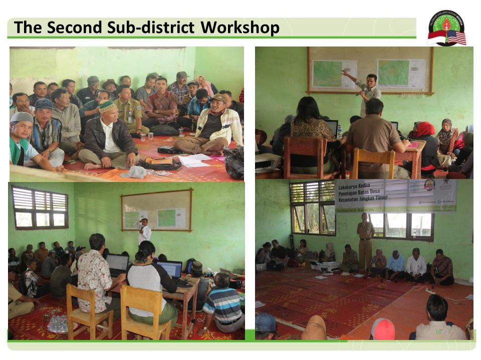
23
After the chartometric map is finished, the village participation team present the map in the second sub-district workshop (a village may have not concluded all the village boundaries) Some of the remaining dispute boundaries could be settled during the workshop the participants develop village boundary survey planning to determine and demarcate the village boundary by identifying the coordinate of village boundary (many boundaries could be surveyed and many of them could not be surveyed – only to determine chartometric point) The Second Sub-district Workshop
 Some of the remaining dispute boundaries could be settled during the workshop the participants develop village boundary survey planning to determine and demarcate the village boundary by identifying the coordinate of village boundary (many boundaries could be surveyed and many of them could not be surveyed – only to determine chartometric point) The Second Sub-district Workshop")
25
Village Boundary Survey

26
Findings Village boundary can be settled through voluntary and participatory approach. The participation of the district government is an important part of the process to give formal legitimacy after the participatory process is fulfilled. Independent, Voluntary, Participatory and Transparent based dispute resolution settlement is a very effective instrument to resolve the boundary disputes. The boundary disputes are the impact of the village division that are not delineated accurately and properly and several cases are not consulted with all neighboring villages.

27
Findings - Continued Establishment of new villages are the expansion of location of ex-transmigration program many year ago without accurate delineation of village boundary. Village boundary dispute can be more easily settled if there is no "immediate/imminent economic benefits" on the disputed part of villages. Need to improve and increase community understanding on village boundary as only administrative instrument not a territorial or ownership of the community. People still own their land even though the land is located out of their villages. Village boundary dispute of neighboring villages whose people are from the same community groups/culture are more easily settled.

28
Conclusion and Recommendation VBS/RM is an effective tool to determine administrative village boundary through participatory and formal approach VBS/RM is not only clarifying “administrative boundary” but also settling boundary dispute among neighboring villages VBS/RM helps local government in developing better development policy in village affairs VBS/RM enhances awareness of local community on spatial knowledge and importance of definite village boundary

Presentasi serupa
>")


 736711, Website:>")


 2. Mahasiswa mampu memahami metode membaca.>")


 : ADALAH CABANG MATEMATIKA YANG MEMPELAJARI PENGATURAN OBJEK- OBJEK. ADALAH CABANG.>")


