Upload presentasi
Presentasi sedang didownload. Silahkan tunggu

1
TIM SUB SISTEM ALAMIAH: KELAUTAN (MARINES)
PENGANTAR ILMU PERIKANAN DAN KELAUTAN: SUB SISTEM KELAUTAN (MARINES) SUB SISTEM ALAMIAH PERIKANAN: 1. BIOSISTEM KELAUTAN 2. BIOSISTEM PERAIRAN TIM SUB SISTEM ALAMIAH: KELAUTAN (MARINES)
 SUB SISTEM ALAMIAH PERIKANAN: 1. BIOSISTEM KELAUTAN 2. BIOSISTEM PERAIRAN. TIM SUB SISTEM ALAMIAH: KELAUTAN (MARINES)")
2
POKOK BAHASAN PENGERTIAN LAUT, SAMUDERA, BEBERAPA ISTILAH KELAUTAN.
2. PEMBAGIAN WILAYAH LAUT SECARA VERTIKAL DAN HORIZONTAL 3. BENTUK-BENTUK EKSPLOITASI OLEH MANUSIA UNTUK MEMANFAATKAN LAUT SBG SDA

3
NATURAL ECOSYSTEM: Community Fish species Habitat External forces
(e.g. climate change) Aquatic environment The structure of natural sub-system: fish sp interact with ecosystem, & in turn with biophysical environment. External forces impact on entire system (Charles, 2001)
 Aquatic environment. The structure of natural sub-system: fish sp interact with ecosystem, & in turn with biophysical environment. External forces impact on entire system (Charles, 2001)")
4
POKOK BAHASAN PENGERTIAN LAUT, SAMUDERA, BEBERAPA ISTILAH KELAUTAN.
LAUT: Kumpulan air asin dalam jumlah banyak dan luas yang menggenangi dan membagi daratan atas benua atau pulau. jadi Laut adalah air yang menutupi permukaan tanah yang sangat luas dan umumnya mengandung garam dan berasa asin. POKOK BAHASAN PENGERTIAN LAUT, SAMUDERA, BEBERAPA ISTILAH KELAUTAN. PEMBAGIAN WILAYAH LAUT SECARA VERTIKAL DAN HORIZONTAL BENTUK-BENTUK EKSPLOITASI OLEH MANUSIA UNTUK MEMANFAATKAN LAUT SBG SDA Laut: seluruh badan air asin yang saling berhubungan dan menutupi 70,78 % dari permukaan bumi. Jumlah ini tidak termasuk danau asin (salt lake)
")
5
SEJARAH TERBENTUKNYA LAUT:
OCEAN: (Okeanos)= Samudera (Atlantik, Hindia, Pasifik, Artic(k) atau SEA dan MARINE = Laut MARINE VS TERRESTRIAL (Daratan) SEJARAH TERBENTUKNYA LAUT: Laut terbentuk 4,4 miliar tahun yg lalu. Awalnya bersifat sangat asam dengan air yang mendidih (suhu 1000C). Mengapa asam krn atmosfir bumi dipenuhi oleh CO2. Keasaman air inilah yang menyebabkan tingginya pelapukan yang terjadi yang menghasilkan garam-garam yang menyebabkan air laut menjadi asin seperti sekarang ini. Pasang surut laut terjadi karena jarak bulan yang begitu dekat dengan bumi.
= Samudera (Atlantik, Hindia, Pasifik, Artic(k) atau SEA dan MARINE = Laut. MARINE VS TERRESTRIAL (Daratan) SEJARAH TERBENTUKNYA LAUT: Laut terbentuk 4,4 miliar tahun yg lalu. Awalnya bersifat sangat asam dengan air yang mendidih (suhu 1000C). Mengapa asam krn atmosfir bumi dipenuhi oleh CO2. Keasaman air inilah yang menyebabkan tingginya pelapukan yang terjadi yang menghasilkan garam-garam yang menyebabkan air laut menjadi asin seperti sekarang ini. Pasang surut laut terjadi karena jarak bulan yang begitu dekat dengan bumi.")
6
DARI MANA ASAL MUASAL AIR LAUT
bumi mulai mendingin akibat berkurangnya aktivitas vulkanik. Atmosfer bumi saat itu tertutup oleh debu-debu vulkanik yang mengakibatkan terhalangnya sinar matahari untuk masuk ke bumi. Akibatnya, uap air di atmosfer mulai terkondensasi dan terbentuk hujan dan hujan mengisi cekungan-cekungan di bumi hingga terbentuklah lautan. Perlahan-lahan, jumlah karbon dioksida diatmosfer mulai berkurang krn terlarut dalam air laut dan bereaksi dengan ion karbonat membentuk kalsium karbonat. Akibatnya, langit cerah sehingga sinar matahari dapat menyinari bumi. Akibatnya terjadinya proses penguapan dan volume air laut di bumi mengalami pengurangan dan bagian-bagian di bumi yang awalnya terendam air mulai kering. Proses pelapukan batuan terus berlanjut akibat hujan yang terjadi dan terbawa ke lautan, menyebabkan air laut semakin asin.

7
DATA TENTANG LAUT Luas total Permukaan laut: 361 juta Km2;
Rata-rata kedalaman laut: m, Total Volume: miliar Km2. Setiap 1 Km3 air laut setara dengan berat 1,12 miliar ton dan mengandung 40 juta ton bahan terlarut. Kadar garam = salinitas: kandungan garam terlarut = %o . (per seribu). Salinitas air laut bervariasi antara 33 sampai 38 %o dengan rata-rata sekitar 35 %o (atau 35 g pada total 1 Kg air laut). Lebih dari 90 % garam terlarut berasal dari 6 elemen utama: Chlorin (Cl), sodium (Na+) , Magnesium (Mg2+), Sulfrur (SO42-), Calcium (Ca2+) dan Potassium (K+). Dua elemen lainnya: bikarbonat (HCO3+) dan Bromin (Br-)
. Salinitas air laut bervariasi antara 33 sampai 38 %o dengan rata-rata sekitar 35 %o (atau 35 g pada total 1 Kg air laut). Lebih dari 90 % garam terlarut berasal dari 6 elemen utama: Chlorin (Cl), sodium (Na+) , Magnesium (Mg2+), Sulfrur (SO42-), Calcium (Ca2+) dan Potassium (K+). Dua elemen lainnya: bikarbonat (HCO3+) dan Bromin (Br-)")
8
DASAR LAUT Memiliki Topografi bergelombang;
Laut memiliki “Sea Mount” (Gunung laut). Ada gn laut yang tidak terlihat ada yang terlihat. Gunung tertinggi yg muncul dari dasar laut: Gunung Mauna Kea (Hawai). Tinggi m dari dasar laut;
. Ada gn laut yang tidak terlihat ada yang terlihat. Gunung tertinggi yg muncul dari dasar laut: Gunung Mauna Kea (Hawai). Tinggi m dari dasar laut;")
9
Untuk setiap penurunan meter dari permukaan laut, tekanan akan turun hingga satu atmosfer. Maka, untuk kedalaman hingga meter tekanannya mencapai 650 atmosfer. Selain itu, di laut dalam juga tidak ada sinar Matahari dan oksigen atau hidup dalam kondisi anaerob.

10
SUHU AIR LAUT Suhu air laut tergantung pada kedalaman dan posisi lokai. Suhu air laguna dangkal mencapai 370 C pada siang hari. Suhu air laut disekitar equator 24 – 29 o C. Suhu air laut di kutub: 0 – 4oC Sekitar 87 % air laut mempunyai rata-rata suhu 4,40 oC. Thermocline: menjelaskan suatu wilayah pada kedalaman air laut, dengan perbedaan suhu yang tinggi. Semakin jauh kedalam, suhu air laut menurun secara drastis dibanding wilayah diatas maupun dibawahnya.

11
Water Body Area (x108 Km2) % of Earth Surface Vol (x 106 Km3) % Vol of World Ocean Mean Depth Atlantic 82.4 16.2 323.6 23.6 3,926 Pacific 165.3 32.4 707.6 51.6 4,282 Indian 73.4 14.4 291.0 21.2 3,936 Artic Sea 9.5 2.8 9.41 1.2 991 Mediterr. 2.9 4.2 1,429 Others 5.1 2.4 Gulf of Mexico 0.44 0.077 180 Caspian Sea 0.16 0.13 813 Lake Superior 0.08 0..12 149

12
Kenampakan dasar laut apakah datar? Apakah bergelombang? Atau bergunung? Apa yang dilihat didarat sama seperti apa yang dilihat didasar laut: pegunungan, lembah, datar, berbukit.

13
Ada gunung paling tinggi, ada lembah paling dalam dan ada daratan semua ada didasar laut.
Note the mountain chains (purple) that weave through all the oceans. These are the mid-ocean ridges.
 that weave through all the oceans. These are the mid-ocean ridges.")
14
Features of the Ocean Floor
Continental shelf: surrounds the continent as a shallow extension of continental crust extending out to the continental slope. Continental slope: steep drop-off at the end of the continental shelf that connects the continental crust to the oceanic crust. Together, they make up the continental margin. The continental shelf is under water, but fairly shallow. Most commercial fisheries are over the continental shelf or at the shelf break. The continental rise is the mound of accumulated sediments from the land that fell down the slope and are being carried away by action of currents.

15
Features of the Ocean Crust
Abyssal plains: are the flattest areas on earth. Ocean ridges: are long mountain ranges formed when magma seeps or erupts between pieces of the Earth’s crust (tectonic plates). Trenches: are the deepest part of the ocean and are formed when one tectonic plate is forced under another tectonic plate. Seamounts: isolated volcanic mountains which erupt under the ocean. Large ones are islands. Guyots: are extinct volcanoes with eroded flat tops.
. Trenches: are the deepest part of the ocean and are formed when one tectonic plate is forced under another tectonic plate. Seamounts: isolated volcanic mountains which erupt under the ocean. Large ones are islands. Guyots: are extinct volcanoes with eroded flat tops.")
16
The highest mountain on Earth is Mauna Kea, Hawaii, a seamount
Ocean ridges form a mountain chain 40,000 miles long through all the oceans The highest mountain on Earth is Mauna Kea, Hawaii, a seamount The average depth of the ocean is 12,200 feet (3,720 m.) Mauna Kea is 33,474 ft. tall from the seabed (10,203 m.), but only 13,680 ft. (4,170 m.) above sea level. Mount Everest is about 29,000 ft. tall, but all above sea level. The ocean ridge is the largest single feature on Earth. A rift valley is the area where the plates are separating and moving apart. Magma erupts here and builds up the ocean ranges on both sides.
 Mauna Kea is 33,474 ft. tall from the seabed (10,203 m.), but only 13,680 ft. (4,170 m.) above sea level. Mount Everest is about 29,000 ft. tall, but all above sea level. The ocean ridge is the largest single feature on Earth. A rift valley is the area where the plates are separating and moving apart. Magma erupts here and builds up the ocean ranges on both sides.")
17
Trenches form where tectonic plates (chunks of the Earth’s crust) are forced under another plate.
The Mariana Trench in the western Pacific is the deepest point on Earth– 36,198 ft. (11,033 m.) Most trenches are in the Pacific Ocean, which is more active geologically. Mariana’s Trench is deeper than Mount Everest or Mauna Kea are tall.
 Most trenches are in the Pacific Ocean, which is more active geologically. Mariana’s Trench is deeper than Mount Everest or Mauna Kea are tall.")
18
Trieste and the Mariana Trench
In 1960, the US Navy sent a small submersible (mini-sub) to see how far down it could go. It sat on the bottom at 35,838 ft. (10,923 m.) The sailors had 7 miles of water over their heads! The Trieste was designed by a hot air balloonist. Jacques Piccard. The tiny sphere below the sub is where Piccard and a Navy officer were. Their journey to the bottom of Challenger Deep has never been equaled by men.
 to see how far down it. could go. It sat on the. bottom at 35,838 ft. (10,923 m.) The sailors had. 7 miles of water over their. heads! The Trieste was designed by a hot air balloonist. Jacques Piccard. The tiny sphere below the sub is where Piccard and a Navy officer were. Their journey to the bottom of Challenger Deep has never been equaled by men.")
19
Our life does not run without ocean.
Weather and climate Fishery Shipping

20
MANFAAT LAUT BAGI KEHIDUPAN
Penangkapan ikan atau perikanan laut (ikan menyediakan 20 % kebutuhan protein bagi 50 % penduduk dunia.; Laut mengandung sumber mineral. Ada 73 jenis dari 93 mineral alam. Natrium, chlorida, magnesium, bromine, iodium ,dll. Sebagai pembentuk iklim dunia (air-sea interaction, ocean phenomenon: El Nino. La Nina, Indian Ocean Dipole, etc.). Sebagai sarana kegiatan manusia, misal shipping (trading, transportation, ocean training, observation, etc.) Fishery (fishing, marine culture, fish rancing, etc.) Sumber Makanan (productivity sources: plankton, coral, algae, small and big fishes, etc.) Sumber Energi (gelombang, mining, bioenergy (algae), Pharmacy (gamete: anti aging, algae: anti cancer) Tourism, etc.....
. Sebagai sarana kegiatan manusia, misal shipping (trading, transportation, ocean training, observation, etc.) Fishery (fishing, marine culture, fish rancing, etc.) Sumber Makanan (productivity sources: plankton, coral, algae, small and big fishes, etc.) Sumber Energi (gelombang, mining, bioenergy (algae), Pharmacy (gamete: anti aging, algae: anti cancer) Tourism, etc.....")
22
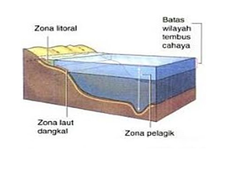
PELAGIC: Epipelagic: m Mesopelagic : 200 – 1000 m Bathypelagic: 1000 – 2000 m Abyssalpelagic 2000 – 6000 m Hedalpelagic: > 6000 m BENTHIC: Litoral: Intertidal Sublitoral: 0 – 200 m Bathyal : 200 – 2000 m Abyssal: 2000 – 6000 m Hadal > 6000 m STRUKTUR TOPOGRAFI DASAR LAUT, KEDALAMAN, KOLOM AIR DIATASNYA DAN EFEKTIVITAS SINAR MATAHARI

23
PELBAGAI ISTILAH COAST LINE (garis pantai) atau SHORELINE: Batas air laut terakhir mencapai darat dan bersifat dinamis tergantung pasang surut.. Menurut kedalamannya, ekosistem air laut dibagi sebagai berikut: LITORAL: merupakan daerah yang berbatasan dengan darat. NERETIK merupakan daerah yang masih dapat ditembus cahaya matahari sampai bagian dasar dalamnya ± 300 meter. BATIAL merupakan daerah yang dalamnya berkisar antara m. ABISAL merupakan daerah yang lebih jauh dan lebih dalam dari pantai ( m).
.")
24
Four Zones of Interest Pelagic Intertidal Abyssal Benthic
Earth is typically divided into “-spheres”: hydrosphere refers to water, lithosphere to the landforms (“litho” means rock), biosphere to the living world (“bios” means living), and the atmosphere (“atmos” means air). Four zones of interest in the hydrosphere are intertidal, pelagic, abyssal, and benthic.
, biosphere to the living world ( bios means living), and the atmosphere ( atmos means air). Four zones of interest in the hydrosphere are intertidal, pelagic, abyssal, and benthic.")
25
Air apapun di laut yang tidak terlalu dekat dengan dasar laut dinamai zona pelagik
KEDALAMAN DAN LAPISAN ZONA PELAGIK Epipelagik Dari permukaan (Mean Sea Level) hingga kedalaman 200 m (656 kaki). Mesopelagik Dari kedalaman 200 m turun ke m (3.280 kaki). Batipelagik Dari kedalaman m turun ke sekitar m ( kaki). Abisopelagik Dari kedalaman m turun ke di atas dasar laut. Hadopelagik Air dalam di palung samudera.
 hingga kedalaman 200 m (656 kaki). Mesopelagik Dari kedalaman 200 m turun ke m (3.280 kaki). Batipelagik Dari kedalaman m turun ke sekitar m ( kaki). Abisopelagik Dari kedalaman m turun ke di atas dasar laut. Hadopelagik Air dalam di palung samudera.")
26
Pelagic Zone Notice in this cartoon the pelagic zone extends to 4000 meters. Different charts use different depths to divide zones; there isn’t an accepted standard. Photic means “sunlit”; disphotic means “twilight” or “low light”; aphotic means “no light”. Photosynthesis only takes place in the sunlit zone, which varies in depth depending on the clarity of the water.

27
Inhabitants of the Pelagic Zone
Notice the depth divisions are different. What you need to know is abyssal is very deep, very cold, completely dark, and under tremendous pressure because of the depth. Use whatever depths your textbook uses. Turtles, seahorses, jellyfish, plankton, whales, sharks, large and small fish, and squid abound in the pelagic (open water).
.")
28
A Pelagic Food Web Everything begins with sunlight for the phytoplankton and other photosynthetic organisms.

29
Dolphins, school of fish, submersible, sea turtles, shark, sperm whale, shark, seahorse, giant squid, sea turtle, plankton, eye of giant squid. Sperm whales dive very deep to eat the giant squid.

30
BENTHIC PELAGIC The organisms in blue are pelagic; the organisms on the orange are all benthic. Pelagic– open water– swimming around. Benthic– in or on the bottom.

31
ZONA INTERTIDAL: Zona intertidal merupakan zona yang dipengaruhi oleh pasang surut air laut dengan luas area yang sempit antara daerah pasang tertinggi dan surut terendah. Pada zona ini terdapat variasi faktor lingkungan yang cukup besar, seperti fluktuasi suhu, salinitas, kecerahan dan lain – lain. Variasi ini dapat terjadi pada daerah yang hanya berjarak sangat dekat saja misalnya beberapa cm. Zona ini dihuni oleh organisme yang keseluruhannya merupakan organisme bahari. t

32
Intertidal zone creatures
High Tide Some organisms need a hard bottom to attach to. Our beaches are generally sandy, without hard substrate, but piers, docks, boat ramps, bulkheads, etc. do provide hard bottom. Many of these organisms are motile (can move around) rather than attached– crawlers, grazers, burrowers, swimmers. Low Tide
 rather than attached– crawlers, grazers, burrowers, swimmers. Low Tide.")
33
INTEREST OF FISHERIES Fished species Fish Shellfish (kerang2an)
Others: Echinoderms (bintang laut, landak laut), elasmobranchs (hiu, sinar), porifera (hewan berpori), etc. Fish Shellfish (kerang2an) Demersal (jenis ikan habitatnya dibagian dasar perairan Pelagic Ikan yg umumnya berenang dng kedalaman 200m Crustaceans (hewan akuatik terdpt di air laut dan tawar Molluscs (Kel hewan invertegrata yg memiliki tubuh lunak Herring, Mackerel, Sharks, Salmon, Etc Berdasarkan ukuran: ikan pelagis besar kel Tuna dan cakalang, kel Marlin, Kelompok tongkol dan Tenggiri) Cod, Flatfish, Ocean Perch, Catfish, etc Decapods:shirmp/prawn, crawer (lobster & crab), others (krill) Gastropods (abalon) Bivalve (clams) Chepalopods (squid)
, elasmobranchs (hiu, sinar), porifera (hewan berpori), etc. Fish. Shellfish. (kerang2an) Demersal. (jenis ikan habitatnya dibagian dasar perairan. Pelagic. Ikan yg umumnya berenang dng kedalaman 200m. Crustaceans. (hewan akuatik terdpt di air laut dan tawar. Molluscs. (Kel hewan invertegrata yg memiliki tubuh lunak. Herring, Mackerel, Sharks, Salmon, Etc. Berdasarkan ukuran: ikan pelagis besar kel Tuna dan cakalang, kel Marlin, Kelompok tongkol dan Tenggiri) Cod, Flatfish, Ocean Perch, Catfish, etc. Decapods:shirmp/prawn, crawer (lobster & crab), others (krill) Gastropods (abalon) Bivalve (clams) Chepalopods (squid)")
34
PELAGIS DEMERSAL Kelompok Ikan yg berada pada lapisan permukaan hingga kolam air dan memiliki ciri khas utama selalu bergerombol (schooling) dan melakukan migrasi. Ikan pelagis besar: Tuna, cakalang, tongkol, cucut; diketemukan di tubiran karang atau tubiran dimana arus hangat dekat perairan pantai. Pakai teknik memancing: pancing trolling atau tonda Ikan pelagis kecil: ikan layang, teri, kembung. Lemuru, dan ditangkap pakai jaring lingkar, pukat cicin, payang, bagan, pukat tepi Ikan pelagis disebut ikan berminyak dijaringan tubuh dan dalam rongga perut disekitar usus Jenis ikan yang habitatnya berada di bagian dasar perairan; Ditangkap dengan alat tangkap ikan dasar seperti trawl dasar, jaring insang dasar (bottom gillnet), rawai dasar (bottom long line) bubu. Kakap merah/bambangan (Lutjanus spp), peperek (leiognatus spp), kurisi (nemipterus spp), kuniran (Upenus spp), tiga waja (Epinephelus spp), bawal (Pampus Spp).
 dan melakukan migrasi. Ikan pelagis besar: Tuna, cakalang, tongkol, cucut; diketemukan di tubiran karang atau tubiran dimana arus hangat dekat perairan pantai. Pakai teknik memancing: pancing trolling atau tonda. Ikan pelagis kecil: ikan layang, teri, kembung. Lemuru, dan ditangkap pakai jaring lingkar, pukat cicin, payang, bagan, pukat tepi. Ikan pelagis disebut ikan berminyak dijaringan tubuh dan dalam rongga perut disekitar usus. Jenis ikan yang habitatnya berada di bagian dasar perairan; Ditangkap dengan alat tangkap ikan dasar seperti trawl dasar, jaring insang dasar (bottom gillnet), rawai dasar (bottom long line) bubu. Kakap merah/bambangan (Lutjanus spp), peperek (leiognatus spp), kurisi (nemipterus spp), kuniran (Upenus spp), tiga waja (Epinephelus spp), bawal (Pampus Spp).")
35
Do you recognize these organisms. The first two are sponges
Do you recognize these organisms? The first two are sponges. The crab is a mangrove crab, related to our fiddler crabs with one big claw. Mangroves are intertidal, with a whole group of animals that inhabit the mud flats when the tide is out. We see a lot of hermit crabs on our shores– crabs that live in discarded gastropod shells. The orange disk on the gastropod is its “trap door”, which it pulls shut to keep from drying out during low tide. Gastropods are snails that secrete spiral shells. The plants that look like palm trees are seaweeds with holdfasts to cling to the rocks. The corner picture is anemones– where’s Nemo?

36
Another view– zones in zones
Notice that some are benthic– live in or on the bottom– rather than swimming around above it.

37
ZONES OF THE WATER COLUMN
Abyssal: Zona abisal adalah suatu zona di dasar laut yang amat dalam, dimulai dari kedalaman 1000 meter sampai 6000 meter.Zona ini termasuk kedalam lubuk laut dan palung laut.[1] Tekanan air laut sudah besar sehingga hanya sedikit binatang-binatang laut yang dapat hidup di zona ini.

38
Monsters of the Abyss

39
The Abyss A very hostile environment
Increasing Cold Increasing Pressure The average ocean depth is around 12,000 ft. so much of the ocean is abyssal. Because of the intense pressure and lack of food, the abyss has less life than more hospitable environments– but far more than scientists thought at one time, when they thought the ocean bottom was devoid of life.

40
Fantastic Denizens of the Deep
Notice the large gaping mouths to take advantage of any food that falls from above. Most organisms are small and do not have muscular bodies– with the extreme cold, lack of food, and low oxygen, they don’t chase around preying on other organisms. The first two pictures on the bottom row are vampire squids. Denizens is just another word for inhabitants. Fantastic Denizens of the Deep

41
ZONES OF THE WATER COLUMN
Benthic: a term meaning bottom, is the ocean zone ranging from the deepest part of the ocean to the shore. Many kinds of organisms live in the benthic zone– plants, anemones, sponges, fish, skates and rays, octopus, mollusks, crabs, sea stars, corals and worms. Most are scavengers. In the deep ocean, there are special benthic communities around hydrothermal vents whose energy comes from chemical reactions rather than from the sun.

42
Benthic Zone– from the shore to the depths

43
BENTHIC PELAGIC The organisms in blue are pelagic; the organisms on the orange are all benthic. All parts of the ocean are inhabited.

44
Intertidal Benthic Coral Reef
All benthic communities. Hydrothermal vent

45
Ratfish and ray, octopus, anemone, sea star, sea urchin, group of shells and mole crab, crab, soft coral and flatworm (black with ruffly edges), group of shells and spider crab, spiny oyster.
, group of shells and spider crab, spiny oyster.")
46
Hydrothermal Vents In 1977, the submersible Alvin
found seafloor vents that were gushing hot mineral-rich water in the midnight depths of the ocean. Cold sea water seeps into cracks in the Earth’s crust and is superheated by the magma in the mantle. The hot water with dissolved minerals from the magma rises and spews out like an undersea geyser . Magma is molten rock. If magma erupts, it is called lava.

47
Cold water and chemical reactions cause mineral
deposits to settle out as vent chimneys. Fantastic communities of organisms that live by chemosynthesis thrive around these “black smokers”, using energy from chemical reactions with minerals in the water to live. The first picture is Alvin by a vent chimney, with tube worms in the foreground. The second picture is a “black smoker” or vent chimney. The next is giant tube worms (some as large as 8 ft.) and crabs. Chemosynthesis means to make with chemicals, as opposed to photosynthesis which is make with light. In this sunless environment, bacteria use hydrogen sulfide and other chemicals dissolved in the hot water to create organic molecules.
 and crabs. Chemosynthesis means to make with chemicals, as opposed to photosynthesis which is make with light. In this sunless environment, bacteria use hydrogen sulfide and other chemicals dissolved in the hot water to create organic molecules.")
48
ZONES OF THE WATER COLUMN
Life in the deepest parts of the ocean is fairly sparse except around hydrothermal vents, where it is quite concentrated.

49
Pelagic Intertidal Abyssal Benthic

50
OCEAN ZONES OCEAN COMMUNITIES ZONES OF THE WATER COLUMN
FEATURES OF THE OCEAN FLOOR OCEAN COMMUNITIES

51
Ocean Biomes Can be divided by zones: intertidal, pelagic, and abyssal. Benthic organisms are the bottom dwellers in each zone. Each zone requires different adaptations for survival. Organisms are specialized to live in a particular zone. Like in land biomes, similar types of flora and fauna live in similar types of biomes across the world oceans. Aquatic biomes can be described by their salinity (salty, fresh, or brackish). Ocean biomes are defined by the zones in which the organisms live.
. Ocean biomes are defined by the zones in which the organisms live.")
52
Other Aquatic Biomes “Aquatic” means water.
Other aquatic biomes besides the ocean (marine biome) are freshwater and estuarine. Freshwater is water with no salt, and includes rivers, lakes, ponds, etc. Estuaries are environments where salt water and fresh water meet. The salinity (amount of salt) varies with the tides and the seasons. Estuaries are often warm, shallow, protected places that serve as nurseries for marine organisms. Mobile Bay where Alabama rivers meet the Gulf of Mexico, is the fourth largest estuary in the United States. Most of the seafood caught in the Gulf of Mexico– shrimp, crabs, oysters, some fish– depend on estuaries. Another word for estuarine waters is brackish, which means it has some salt.
 are freshwater and estuarine. Freshwater is water with no salt, and includes rivers, lakes, ponds, etc. Estuaries are environments where salt water and fresh water meet. The salinity (amount of salt) varies with the tides and the seasons. Estuaries are often warm, shallow, protected places that serve as nurseries for marine organisms. Mobile Bay where Alabama rivers meet the Gulf of Mexico, is the fourth largest estuary in the United States. Most of the seafood caught in the Gulf of Mexico– shrimp, crabs, oysters, some fish– depend on estuaries. Another word for estuarine waters is brackish, which means it has some salt.")
53
Freshwater Marine Estuary

54
THE PHYSICAL–CHEMICAL ENVIRONMENT
Ecosystems Living Creatures Physical Creatures Winds Ocean Currents Upwelling Tides Freshwater-saltwater interactions

55
THE PHYSICAL–CHEMICAL ENVIRONMENT
The Winds Ocean Currents Upwelling Other relatively localized phenomena (tidal currents, freshwater-saltwater interactions)
")
56
The Winds All the major surface currents in the oceans are created by the drag of the wind on the surface water. The winds, in turn, are created because the earth’s surface is heated unevenly by the sun, making the tropical regions warm and the polar regions cold. (Mann & Lazier 1996, p.242)
")
57
Pembangkitan Gelombang oleh Angin
Angin yang berhembus di atas permukaan air akan memindahkan energinya ke air Kecepatan angin akan menimbulkan tegangan pada permukaan laut timbul riak gelombang kecil di permukaan air Apabila kecepatan angin bertambah, riak tersebut menjadi semakin besar, apabila angin berhembus terus akhirnya akan terbentuk gelombang Semakin lama dan semakin kuat angin berhembus, semakin besar gelombang yang terbentuk

58
Data Angin Kecepatan angin di ukur dengan anemometer
(biasanya dinyatakan dalam knot) ( 1 knot = km/jam= 0.5 m/s) Untuk mempermudah dalam membaca karakteristik angin,
 ( 1 knot = km/jam= 0.5 m/s) Untuk mempermudah dalam membaca karakteristik angin,")
59
Wind Rose

60
Upwelling (menaiknya massa air laut dari lapisan bawah permukaan d= m, krn proses fisik perairan) Upwelling occurs when surface water is swept by the wind away from the coast and this is replaced by deeper water rising to the surface close to shore Localised settings, seabed topography may deflect bottom currents towards the surface.

61
Upwelling and sinking ocean currents are driven by offshore and onshore winds.

62
~Terima kasih ~

Presentasi serupa


 MASSA PADAT DENGAN INTI MAGMA>")


 Materi Kuliah 8>")

