Upload presentasi
Presentasi sedang didownload. Silahkan tunggu

1
Penentuan Posisi Dasar:
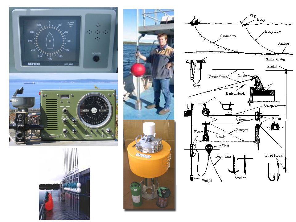
Membaring benda darat (Gunung; Bangunan; Tanjung / Ujung) Membaring benda laut (Buoy; Kapal karam) Membaring Benda-benda angkasa (Bintang; Matahari; Bulan) Membaring Sinyal Radio Perangkat: Kompas Sextant Radar RDF (Radio Direction Finder) Loran / Decca / Omega Reader (Radio Base Transmitter) GPS Directed Antenna
 Membaring benda laut (Buoy; Kapal karam) Membaring Benda-benda angkasa (Bintang; Matahari; Bulan) Membaring Sinyal Radio. Perangkat: Kompas. Sextant. Radar. RDF (Radio Direction Finder) Loran / Decca / Omega Reader (Radio Base Transmitter) GPS. Directed Antenna.")
2
Baring 2 Baring 1 Haluan

3
Penetuan Posisi Konvensional:

4
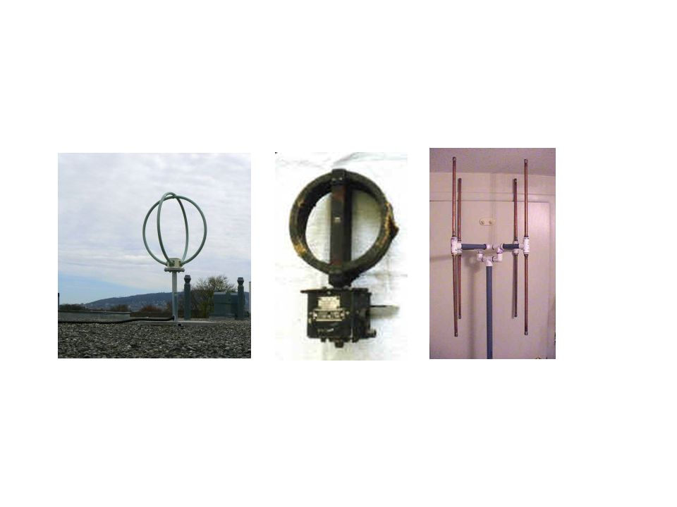
Radio Direction Finder
RADIO-BUOY / BEACON Radio Direction Finder

7
RADAR

8
Contoh-contoh: Radar pada Air Traffic Contol

11
Marine Radar Untuk: Penentuan posisi (pembaringan benda-benda)
Mengetahui kondisi Cuaca melalui faktor keawanan dan hujan Posisi pengamatan: Land/sea base Airborne (pesawat, Satelit, Space-lab)
")
12
Contoh-contoh: Radar pada Air Traffic Contol

13
Contoh-contoh: Satellite Radar Image
Radar images obtained by satellites have a wide range of applications. Radar devices provide invaluable information to navigators and meteorologists on water currents and weather conditions. This satellite radar image shows Holland’s Frisian Isles surrounded by the North Sea.

14
Contoh-contoh: Doppler radar measures the speed and direction of the movement of clouds, in addition to cloud density. In this image of a thunderstorm over Oklahoma, Doppler radar shows a mesocyclone, a rotating mass of air that may signal that the formation of a tornado is imminent. Microsoft ® Encarta ® © Microsoft Corporation. All rights reserved.

15
most radar systems are specialized to do one type of tracking or detection
![]()
16
Problema pada land/sea base radar:
Kelengkungan bumi membatasi Distorsi sinyal akibat kemagnetan bumi Distorsi sinyal akibat listrik di awan Kandungan air di awan

17
BASIC RADAR CALCULATION

18
Perambatan Gelombang EM
Arah rambatan, Energi, Medan Magnet

19
RADAR-BEAM w h h w Total response Antenna = k = 2p/l
Linear response “w”= [Sin(k x w/2 x sin w)] / (k x w/2 x sin w) w Linear response “h”= [Sin(k x h/2 x sin h)] / (k x h/2 x sin h) h h w Total response Antenna = {[Sin(k x w/2 x sin w)] / (k x w/2 x sin w)} x {[Sin(k x h/2 x sin h)] / (k x h/2 x sin h)}
] / (k x w/2 x sin w) w. Linear response h = [Sin(k x h/2 x sin h)] / (k x h/2 x sin h) h. h. w. Total response Antenna = {[Sin(k x w/2 x sin w)] / (k x w/2 x sin w)} x. {[Sin(k x h/2 x sin h)] / (k x h/2 x sin h)}")
20
Rentang Frekuensi: 1. Very High Frequency (VHF) band, 150 MHz 2. Extra High Frequency band, 95 GHz Tipe pendeteksian: Tracking Detection. Tracking radar: - Higher frequencies (provide better resolution) - Sharper beam formed (better antenna is) Tracking radar, which precisely locates objects and tracks their movement, needs higher resolution and so uses higher frequencies. On the other hand, if a radar system is used to search large areas for targets, a narrow beam of high-frequency radar will be less efficient. Because the high-power transmitters and large antennas that radar systems require are easier to build for lower frequencies, lower frequency radar systems are more popular for radar that does not need particularly good resolution.
 - Sharper beam formed (better antenna is) Tracking radar, which precisely locates objects and tracks their movement, needs higher resolution and so uses higher frequencies. On the other hand, if a radar system is used to search large areas for targets, a narrow beam of high-frequency radar will be less efficient. Because the high-power transmitters and large antennas that radar systems require are easier to build for lower frequencies, lower frequency radar systems are more popular for radar that does not need particularly good resolution.")
21
Sistem Modulasi: Pulsed Radar Signal dipancarkan dalam bentuk pulsa-pulsa dengan panjang pulsa tertentu. Digunakan untuk mendeteksi target dalam hal Posisi (Time-domain), Karakter sinyal (Intensitas dan Pola frekuensi sinyal echo) [Frekuensi Domain]. Digunakan untuk melihat posisi target atas dasar beda waktu penerimaan pulsa sinyal. Energi Pembangkitannya rendah. Continuous Wave Sial dipancarkan secara terus menerus tanpa jeda. Digunakan untuk melihat karakter sinyal pada pola Karakter sinyal (Intensitas dan Pola frekuensi sinyal echo) [Frekuensi Domain] dan Pola Karakter Fase [Fase Domain]. Digunakan untuk melakukan tracking target dalam hal kecepatan pergerakan berdasarkan pergerseran sinyal atau “Doppler shift”. Energi Pembangkitannya tinggi, perlu sistem dan material yang baik agar tidak overheat dan over capacity.
, Karakter sinyal (Intensitas dan Pola frekuensi sinyal echo) [Frekuensi Domain]. Digunakan untuk melihat posisi target atas dasar beda waktu penerimaan pulsa sinyal. Energi Pembangkitannya rendah. Continuous Wave. Sial dipancarkan secara terus menerus tanpa jeda. Digunakan untuk melihat karakter sinyal pada pola Karakter sinyal (Intensitas dan Pola frekuensi sinyal echo) [Frekuensi Domain] dan Pola Karakter Fase [Fase Domain]. Digunakan untuk melakukan tracking target dalam hal kecepatan pergerakan berdasarkan pergerseran sinyal atau Doppler shift . Energi Pembangkitannya tinggi, perlu sistem dan material yang baik agar tidak overheat dan over capacity.")
22
SIMPLE RADAR TECHNOLOGY
Radioaltimeters, radar devices modified to measure vertical distance only, beam a pulse of electromagnetic radiation downward from the aircraft. A receiving antenna on the craft then detects the radio waves reflected by the surface of the earth. By measuring the time difference (t) between sending and receiving the pulse, the altitude (h) can be computed in the equation h = t x c / 2 c = 3 x 10⁸ m/s Altimeter Tradisional berdasarkan tekanan Aplikasi Simple Radioaltimeter: Pembuatan Peta Topografi Wilayah Darat dan Pesisir menggunakan airborne radioaltimeter via pesawat dan satelit
 between sending and receiving the pulse, the altitude (h) can be computed in the equation. h = t x c / 2. c = 3 x 10⁸ m/s. Altimeter Tradisional berdasarkan tekanan. Aplikasi Simple Radioaltimeter: Pembuatan Peta Topografi Wilayah Darat dan Pesisir menggunakan airborne radioaltimeter via pesawat dan satelit.")
23
Metoda Modulasi Lainnya:
1. Phased Array Radar Radar biasa…. Sinyal dipancarkan dan diterima oleh satu bidang antena yang dapat diputar, atau terus menerus berputar untuk keperluan scanning Phased Array Radar, menggunakan serangkaian radar, dengan antena parabola maupun cambuk. Scanning dilakukan pada kegiatan data processing, guna mengurangi energi operasional.

24
Secondary Radar Adalah radar pasif, atau tidak memancarkan sinyal sama sekali, melainkan bertugas untuk mendeteksi sinyal radar yang datang. Setiap radar komersial saat ini sudah diberikan kode (coded signal) untuk setiap penggunanya. Sehingga pihak bandara, syahbandar atau pengamat perlintasan penerbangan dan pelayaran langsung dapat mengetahui identitas dan posisi pemilik sinyal radar. Umum digunakan oleh ATC.
 untuk setiap penggunanya. Sehingga pihak bandara, syahbandar atau pengamat perlintasan penerbangan dan pelayaran langsung dapat mengetahui identitas dan posisi pemilik sinyal radar. Umum digunakan oleh ATC.")
25
GPS….

26
Aplikasi GPS…..

27
Penentuan Posisi dengan GPS

28
Aplikasi pada Perikanan

29
Aplikasi pada Perikanan
GPS Buoy Posisi, Arah dan Kecepatan Drift GPS-Buoy

30
Problem: Akurasi Pengukuran Posisi didasarkan pada triangulasi posisi Satelit GPS yang berada di orbit bumi secara geo-stasioner. Kondisi Atmosfir sangat mempengaruhi pengukuran. Perlu Landbased Beacon sebagai dasar acuan posisi darat (DGPS)
")
31
GPS is available in two basic forms:
Standard positioning service (SPS) Precise positioning service (PPS). SPS provides a horizontal position that is accurate to about 100 m (about 330 ft); PPS is accurate to about 20 m (about 70 ft). For authorized users—normally the United States military and its allies—PPS also provides greater resistance to jamming and immunity to deceptive signals.
 Precise positioning service (PPS). SPS provides a horizontal position that is accurate to about 100 m (about 330 ft); PPS is accurate to about 20 m (about 70 ft). For authorized users—normally the United States military and its allies—PPS also provides greater resistance to jamming and immunity to deceptive signals.")
32
Enhanced techniques such as differential GPS (DGPS) and the use of a carrier frequency processing have been developed for GPS. DGPS employs fixed stations on the earth as well as satellites and provides a horizontal position accurate to about 3 m (about 10 ft). Surveyors pioneered the use of a carrier frequency processing to compute positions to within about 1 cm (about 0.4 in). SPS, DGPS, and carrier techniques are accessible to all users. Global Positioning System (GPS), space-based radio-navigation system consisting of 24 satellites and ground support.
. Surveyors pioneered the use of a carrier frequency processing to compute positions to within about 1 cm (about 0.4 in). SPS, DGPS, and carrier techniques are accessible to all users. Global Positioning System (GPS), space-based radio-navigation system consisting of 24 satellites and ground support.")
33
TUGAS: Atur GPS dengan interval 30 second Hidupkan selama 5 menit Plot Diferensiasi Posisi GPS Buat hal yang sama dengan total 4 wilayah berbeda (Sudut lapangan Basket IPB)
")
Presentasi serupa


>")


 signals ( pseudo-noise ) signals.>")
>")

>")


>")